Minnesota Weather Plus--A Division of US Weather Plus.
Forecaster: Bohdan Cole
Posting through various channels, and forecaster for multiple sources.
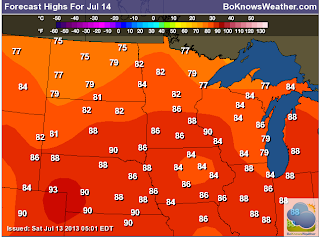
Hello. Many areas of the western Twin Cities area are drying out after getting nearly 5 inches of rain last night--causing flooding issues. Various other severe weather reports came in throughout the day as well. Today could lead to more active weather to the west, and again in MSP overnight. Here is your forecast through July 15th. High Temps, Low Temps, and expected Precipitation. Also, your 7-day Temp/Precip/Wind Forecast is directly below.
Here are your severe weather outlook parameters for today--
General Severe Weather Risk--Main Risk is Slight, throughout a few areas:
Wind/Hail Risk:
Tornado Risk:
Thanks for visiting!
Bo


No comments:
Post a Comment