Minnesota Weather Plus--A Division of US Weather Plus.
Forecaster: Bohdan Cole
Posting through various channels, and forecaster for multiple sources.
Here is another update for today's conditions that are expected in Minnesota. The Severe Weather Risk remains, but likely will be confined to being after dark, especially for the Minneapolis/St.Paul area. We are seeing some daytime storms now, but I expect many of these on the southern edge to weaken. The storms may remain active in Northern MN, near the warm front boundary. As the cool front moves our way tonight, I expect an MCS/Squall line to take shape and move in after dark--possibly after midnight for Eastern MN.
Here are some maps from the Storm Prediction Center that highlight our risks for today:
General Severe Weather Risk: Slight Risk in the area, primarily west of MSP.
Here is the Tornado Risk for the area from SPC:
Here is the Damaging wind risk from SPC:
Here is the Hail risk from SPC--very similar to last map, but some slight variances:
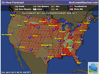
Here is a general forecast outlook for today:
Here are the High and Low Temps that we are expecting today and tonight:
Here is our updated 7 day forecast:
Stay tuned to MN Weather Plus and US Weather Plus for ongoing updates.
Thanks,
Bo


No comments:
Post a Comment